ST Engineering is expanding its satellite development and geospatial analytics capabilities as Singapore builds out its space sector.
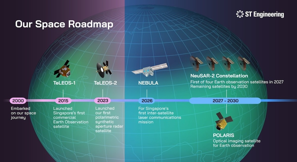
At the Space Summit 2026, ST Engineering announces that it will design and develop satellites in Singapore over the coming years, while rolling out space-enabled solutions that combine earth observation, communications and data analytics. This spans advanced satellite systems and downstream services, underscoring how local industrial players are moving up the space value chain.
The announcements come as Singapore prepares to establish the National Space Agency of Singapore (NSAS). Singapore’s Minister for Manpower and Minister-in-charge of Energy and Science & Technology in the Ministry of Trade and Industry Dr Tan See Leng announced earlier at the summit that the city-state aims to move beyond using space services to becoming “credible contributors to the global space ecosystem”.
One of the most advanced projects in ST Engineering’s pipeline is NEBULA, Singapore’s first pathfinder demonstrator for inter-satellite laser communications.
Scheduled for delivery in the second half of 2026, the NEBULA satellite will be used to test gigabit-per-second data transfers between satellites, a capability that underpins future ultra-fast space networks supporting global broadband, earth observation and secure data exchange.
ST Engineering is also expanding its synthetic aperture radar (SAR) capabilities through the NeuSAR-2 constellation. Four SAR satellites are planned for launch by 2030, with the first expected to enter orbit in 2027.
See also: Singapore’s space push faces cyber risks from legacy satellite systems
The satellites will be "three times lighter" than their predecessors and will deliver "greater orbital agility without compromising performance," says Low Jin Phang, chief operating officer for defence and public security and president of digital systems at ST Engineering, at the summit.
Operating in near-equatorial low Earth orbit, the constellation will provide up to 16 daily revisits along the equatorial belt, supporting applications such as environmental monitoring and disaster response planning.
In parallel, the company will begin research and development on POLARIS, a new optical imaging satellite aimed at real-time earth observation. The platform is expected to feature next-generation capabilities such as onboard artificial intelligence processing to enable faster data analysis by processing information in orbit.
See also: Space partnerships take centrestage as Singapore prepares national space agency
“Our space programme is founded on proven engineering excellence and technical innovation, enabling us to develop more advanced SAR and optical imaging satellites in Singapore for a wide range of missions,” says Low.
Beyond satellites, the company is positioning itself in space operations and analytics.
At the summit, ST Engineering showcased MiNERVA HUB, a space situational awareness platform that integrates space object tracking, conjunction risk analysis and space weather forecasting. The system is designed to help satellite operators manage congestion and mitigate collision risks as orbital traffic increases.
It also introduced Earthsurance, a geospatial assessment and monitoring platform designed to support projects aimed at reducing emissions from deforestation and forest degradation.
ST Engineering's satellite business has been operating for more than 20 years, working with government agencies, national laboratories and local startups to build Singapore's space engineering capabilities.
That experience is now translating into overseas contracts. The company was recently selected to design and deliver an earth observation SAR satellite and mission control infrastructure for a customer in the United Arab Emirates.

